by Richard Pendleton, easement stewardship manager
As an accredited land trust, the Monadnock Conservancy is required to conduct annual monitoring of the properties entrusted to our protection. Since our founding in 1989, we have had the privilege of regularly visiting every property to observe changes on the land and to meet with and build strong relationships with landowners in support of responsible stewardship. Monitoring is one of the most important stewardship responsibilities we hold. It helps ensure that the conservation values protected by an easement—such as forests, wildlife habitat, water resources, and scenic views—are preserved for the future.
Traditionally, annual visits consist of meeting with landowners and walking boundaries, highly used areas, and other unique areas, while looking for changes and documenting any findings. As the number of protected properties has grown, so has the time and expense required for travel, field visits, and reporting. Fortunately, advances in satellite technology now allow us to complement traditional field monitoring with remote observation. This will save resources that can be redirected to landowner support and conservation. Beginning this year, we will be “visiting” a select number of properties remotely using commercially available satellite imagery. Land trusts across the country widely use this approach and the Land Trust Alliance considers it an accepted monitoring practice.
To conduct remote monitoring, we view satellite imagery using Lens, a platform developed by Upstream Tech. Lens provides an integrated system for identifying visible changes and documenting our observations. The software allows us to review and compare aerial photos from different years to look for natural or human-made changes in forest cover, such as harvests, storm damage, or new structures. If we observe unexpected changes, we will follow up with the landowner and conduct a site visit. We typically review imagery early in the year to take advantage of “leaf-off” conditions, which provide clearer views of the land and allow time to follow up on any potential concerns.
Every property is unique, and some are not well suited to remote monitoring alone. For example, a property may require a field visit if evergreen cover obscures large portions, if there are concerns about possible encroachment from neighboring properties, or if a landowner requests an in-person visit. Regardless of the monitoring method used each year, we will visit every property on the ground at least once every five years. We also follow written procedures to ensure that we conduct our monitoring carefully and in accordance with Land Trust Alliance standards.
As an example, the image below shows two satellite photos, side by side, from 2021 and 2025, of one of our conserved properties. We conducted a planned and approved harvest in 2024 to remove dead hemlock trees and diversify the habitat. Diverse forest landscapes are more resistant to disturbances like forest pests and storm damage and encourage more plant and animal diversity. In the images, the harvested areas can be clearly seen. The area to the left of the white line in the lower half of the image was pre-harvest (2021); the area to the right is post-harvest (2025). Note, the open area at the top of the image is wetland and was not harvested. In addition, a buffer with the wetland was preserved.
Our partnership with landowners is a priority relationship for us. We will continue to reach out to landowners each year to support the stewardship of their land. If we plan to monitor remotely, we will let the landowner know and are always happy to schedule an on-the-ground visit in addition to the remote monitoring. We value these meetings with landowners to discuss their goals. Since we can quickly view the property prior to the visit, the use of remote imagery also allows us to spend more time with landowners to talk about the property and their plans.
Because we occasionally receive questions about privacy, it is important to note that the imagery we review comes from commercially available satellite sources that are widely used for mapping and environmental monitoring. We do not use drones or collect imagery ourselves as part of this process. We view images collected in the past, it isn’t real-time. We focus our monitoring on conservation values, not personal activity. The image resolution is around 0.3 to 0.5 meters which translates to being able to discern medium sized structures and vehicles but not individuals. If we find anything of concern, we will reach out to landowners as a first step.
We are excited to adopt this technology as part of our ongoing effort to improve our stewardship practices. This will help us efficiently manage the stewardship of a growing number of conserved properties and focus more staff time on supporting our landowner partnerships.
Any questions? Please feel free to contact Richard Pendleton (richard@monadnockconservancy.org).
Staff Voices: Advancing Land Protection with remote monitoring
Posted Monday, March 23, 2026
—
eNews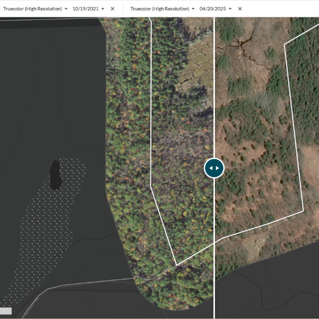
A screenshot of the Lens platform showing an area of an approved patch cut to remove dead hemlock.